
Colorado Hiking Guide | Cap Puckhaber
Welcome to my Colorado Hiking Trail Guide, which covers my trip to Buchanan Pass and the Pawnee Loop.
The Buchanan Pass Pawnee Loop: A World-Class Adventure
When I tell people about the Pawnee-Buchanan Loop I always get that same look. It’s the look that says that sounds cool but also terrifying. I get it. This loop isn’t some leisurely stroll around a lake. It’s a 26.5 mile monster that punches you in the gut with over 6800 feet of elevation gain all in the heart of Colorado’s spectacular Indian Peaks Wilderness. I’d say it’s a spiritual sibling to the famous Four Pass Loop but with an easier entrance from the Denver Boulder area. It’s tough. You’ll breathe hard and your knees will ache but the payoff is something you just don’t forget. If you want to see jagged snow dusted thirteeners and the kind of alpine lakes that make you question whether you’re still on Earth you’ve gotta do this hike. I’m here to tell you that with the right preparation and the right attitude you can absolutely conquer this Colorado classic.
A Reality Check on the Pawnee Buchanan Loop
It’s easy to look at a map and think “Oh it’s only 27 miles I can knock that out in two days.” I’m here to slow your roll a bit. I thought the same thing before my trip but the altitude and the unrelenting steepness of those passes will change your mileage goals real quick. You’re spending a lot of time above treeline often at or near 12000 feet. You’ll need to respect this terrain like it’s your cranky old grandfather. This isn’t just hiking this is high altitude mountain travel that demands your full attention. The reward for all that sweat is traversing the Continental Divide Trail twice. You get bragging rights for having walked from the Atlantic watershed to the Pacific watershed and back.
The Brutal Stats That Tell the Story
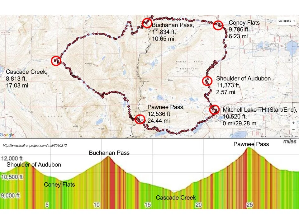
Look I’m not trying to scare you off. I’m trying to prepare you. I know how badly it stinks to hit the trail and realize you totally underestimated the climb. The elevation here is the main antagonist. The trail runs right through the Brainard Lake Recreation Area starting around 10500 feet so you’re already sucking wind before you even take your first big step. Then you have to gain about 1700 feet just to get over Pawnee Pass and another 1700 feet or so for Buchanan. That means two passes above 12000 feet. Most folks take three days and two nights to complete the full circuit comfortably.
These numbers only hint at the experience. You’ll be clambering over boulders navigating loose scree and perhaps even dealing with lingering snow well into July. Consequently this loop is generally rated as difficult to very difficult by most reputable sources like the AllTrails community and guides published by the Colorado Mountain Club’s BPX section. It’s not one for first time backpackers but it’s the perfect challenge for folks who have a few multiday trips under their belts.
FAQs and The Essential Pre Trip Tips
A lot of questions pop up when you plan a trek this serious. Firstly when’s the best time? I can tell you that mid July through early September offers the most reliable weather since the snow is mostly gone. However that’s also when the crowds and the afternoon monsoonal thunderstorms are at their peak. It’s a trade off. Secondly should you go clockwise or counter clockwise? Most people recommend counter clockwise (hitting Buchanan Pass first) because the ascent up Pawnee Pass is famously brutal. Getting it over with on Day 1 lets you approach the rockier more exposed west side of Pawnee Pass on your final day when you’ve burned off some food weight. I chose to go clockwise because of the permit availability so I had to tackle the tough climb on Day 3. You’ll hear more about that later.
One thing I can’t stress enough is to start early every single day. Thunderstorms hit like clockwork around 1 PM in the Colorado high country. You absolutely want to be over any high mountain passes and back below the treeline well before that happens. Lighting at 12000 feet is a truly terrifying experience as I learned the hard way on my own trip up Buchanan. Furthermore before you even consider going you should check out the trail condition reports on sites like backpacker.com or the NPS.gov for the Arapaho and Roosevelt National Forests which manage most of the area. This helps you figure out if that tricky rockfall section on Pawnee Pass is clear or if you need to be prepared for an exposed scramble.
Decoding the Permit Puzzle and Parking Pain
The hardest part of the entire trip arguably is actually securing the right to go. The Indian Peaks Wilderness is one of the most heavily used wilderness areas in the country because it’s so close to Denver and Boulder. They have a strict quota system in place to protect the ecosystem and give people some sense of solitude. Therefore you need two things for an overnight trip during the busy season (typically June 1 to September 15) an overnight camping permit and a parking reservation.
Why You Need to Be a Recreation.gov Ninja
The U.S. Forest Service sells all the overnight permits exclusively through recreation.gov. These permits are released months in advance usually the first Tuesday in March and they disappear faster than a moose in a lightning storm. You need to know exactly which backcountry zones you’ll be camping in for each night like the Crater Lake zone or the Buchanan zone. They don’t allow you to camp just anywhere it must be in a specific zone and at least 100 feet from lakes and streams.
My first attempt at getting a permit was a total flop. I logged on late and all the good zones were gone. I learned quickly to be a Recreation.gov ninja. You should have multiple dates and zones pre selected ready to click the moment they go on sale. I finally snagged a mid week permit for a late August trip by checking for cancellations constantly and I mean constantly. Pro tip a lot of people cancel in the week leading up to their trip so if you miss the initial lottery keep checking the 3 day in advance permits. It really works.
The Brainard Gateway Hack and a Surprise Hitch
Once you have your camping permit you still need a plan for parking. This is an extra layer of complexity that frustrates a lot of people. If you want to park at the Long Lake or Mitchell Lake trailheads inside the Brainard Lake Recreation Area from mid June to mid October you need a separate timed entry permit for your vehicle. They’re super strict about this.
Here’s the thing though if you have an overnight camping permit they will often validate your parking for the entire length of your trip but you still need to reserve the parking spot. It’s confusing so read the fine print on Recreation.gov carefully. However my biggest piece of advice is to use the Brainard Gateway Trailhead (BGT). It’s outside the main fee area and doesn’t require a timed entry reservation. Yes it adds an extra mile or two each way to your overall hike but it’s free and you don’t have to worry about securing yet another ticket. It’s the smart way to handle the logistics. I parked there at 600 AM on Day 1 and had plenty of space saving myself the 11 fee and the hassle.
Day 1 Conquering Buchanan Pass (The Ascent into the Wild)
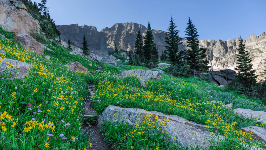
My plan had me going clockwise. That meant tackling the slightly gentler but still substantial climb up Buchanan Pass on Day 1. You start from the Long Lake Trailhead which is a busy area because of the short day hikes to Lake Isabelle. The trail is wide and manicured here but don’t let that fool you. The wilderness is waiting.
The Rocky Start at Brainard Lake Gateway
I’d hiked the extra mile from BGT weaving past day hikers on their way to the famous Lake Isabelle. The energy was high and I felt great. I was carrying a full pack my loadout was around 35 pounds since I’d packed an extra layer for the high altitude. After passing Long Lake the crowds thinned out and the trail got real. This is where you leave the casual stroll behind and commit to the loop. My first real challenge came on the climb up to the Buchanan Pass Trail junction which felt like a deceptively steep warm up.
I remember thinking this isn’t so bad as I hiked past Red Deer Lake. Arrogance is the quickest way to end up miserable in the mountains. The real push starts a few miles beyond the junction as you leave the lush forest and get into the upper basin. This is where the trail turns into a winding unrelenting incline of solid rock and dirt. You just have to put your head down and keep moving.
From Sunshine to Hail in a Colorado Minute
This is a personal anecdote I won’t ever forget. I was maybe a mile below the summit of Buchanan Pass pushing hard when the sky decided to pull a fast one. It was 1100 AM sunny and I was sweating. Ten minutes later a thunderhead that had been hiding behind a distant peak rolled right over us. The temperature plummeted and suddenly pea sized hail was stinging my face. I scrambled to pull on my waterproof shell and pack cover feeling like a total amateur. The storm was fierce but brief.
This is the quintessential lesson of the Pawnee-Buchanan Loop the weather changes so fast. I was so grateful I had followed the classic advice pack a full rain shell even if the forecast says sunny. That sudden cold soak could have been a recipe for hypothermia if I hadn’t been prepared. The key is to be flexible. I sheltered under a small rock outcrop for about thirty minutes until the storm passed. When I finally emerged the sun was out the peaks were glistening with fresh ice and the air smelled incredibly clean. It was a complete shift in mood and a great example of the raw power of the Indian Peaks Wilderness.
A Scary Ledge and the Sound of Music Descent
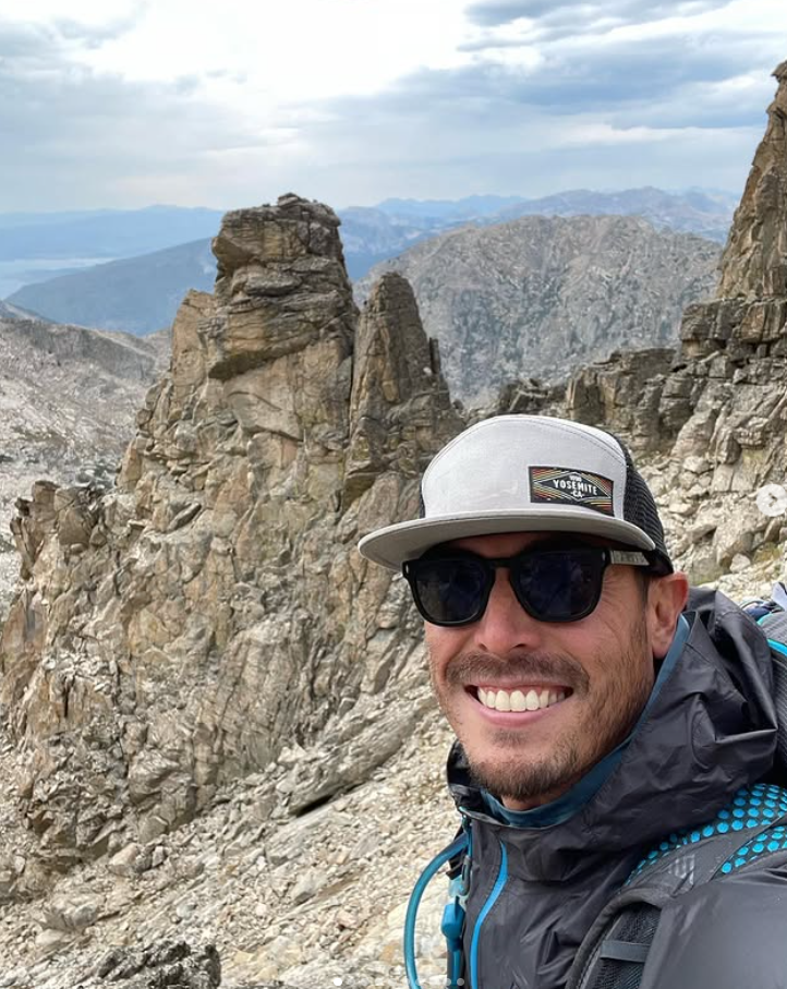
Finally I crested Buchanan Pass at 11837 feet. The view was absolutely stellar. To the east the plains seemed to stretch out forever and to the west the rugged wilderness was a sea of massive peaks. I took my mandatory summit photo then began the descent. The west side of Buchanan Pass is characterized by long beautiful rolling meadows and a deep descent into the Cascade Creek valley.
This descent felt like a huge win but it wasn’t without its challenges. There are a few exposed rocky ledges near the top that require careful footing especially when they’re slick from a passing hailstorm. I found myself having to really lean on my trekking poles here. It’s definitely a Class 2 scramble requiring you to use your hands for balance in a few spots. This is important to note a Class 2 trail means you might need to put a hand down but a fall probably won’t be fatal while a Class 3 trail like some sections of Longs Peak means a fall could be lethal as noted in the guide on REI.com about climbing grades. The descent was long but it took me past massive waterfalls on the Cascade Creek Trail. It felt like walking through a Sound of Music scene complete with vibrant green meadows and rushing water.
The Magic of Fox Park and the Hunt for a Flat Spot
My permit that night was for the Buchanan backcountry zone which is a dispersed camping area that encompasses Fox Park. After a total of about 10.5 miles for the day I was absolutely cooked. Fox Park is what I’d call a quintessential Rocky Mountain high country meadow. It’s huge flat and surrounded by soaring peaks.
Lessons Learned in Campsite Selection
The rule here is to find a designated campsite within the zone that is at least 100 feet from water sources and trails. Since Fox Park is a dispersed camping area I had to search for a pre existing site that showed minimal impact. I spent about forty five minutes walking the meadow which was a huge mistake after a long day and then I finally settled on a spot right at the edge of the tree line. The ground wasn’t perfectly flat and I ended up sleeping with my head slightly lower than my feet which isn’t great for a good night’s rest.
My lesson learned when you’re dead tired it’s easy to settle for a poor campsite but a bad night of sleep can ruin the next day. If you’re planning on camping in the dispersed areas of the Indian Peaks Wilderness use a resource like AllTrails or a detailed map to pre scout potential flat areas near the forest edge. Also be prepared for cold. Even in late August the temperature dropped below freezing. I was happy I had packed my zero degree bag and a warm hat.
Dinner with Deer My Favorite Camp Memory
As I was boiling water for my dehydrated meal a small herd of mule deer ambled out of the trees maybe fifty yards from my camp. They were totally unconcerned with my presence. One doe just watched me with soft eyes as she munched on some alpine grass. It was a beautiful quiet moment that really highlighted why we put ourselves through this kind of physical punishment. This level of intimacy with nature is what the Indian Peaks Wilderness is all about.
I was very careful of course about my food storage. Bear canisters are highly recommended in this area and I had mine secured well away from my tent following the established Leave No Trace guidelines. It’s not just about bears either those little marmots and squirrels will chew through your tent to get to an errant crumb of a protein bar. They are relentless little creatures. Proper food storage is one of the pillars of responsible backpacking and it’s especially vital in high use areas like the Pawnee-Buchanan Loop.
Day 2 Waterfalls Lone Eagle Peak and a Scramble for Camp
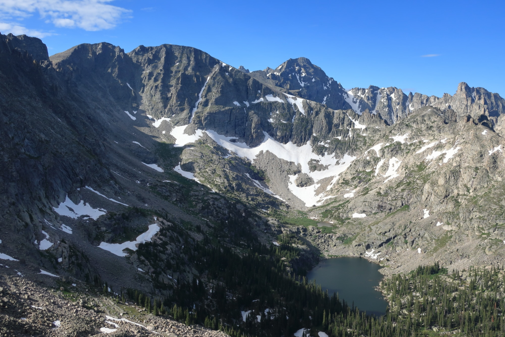
Day 2 was arguably the most scenic of the trip but it was also the longest and the most punishing on my feet. The goal was to hike the length of the Cascade Creek Trail past the famous Crater Lake and then push on to find a site near Pawnee Lake to set up for the final ascent. This day is a study in contrasts you get the lush low valley followed by the stark magnificent alpine basin.
The Cascade Creek Grind and an Unexpected Detour
I started the day early hiking down the Cascade Creek Trail. The water features here are incredible. You hike past numerous waterfalls and through dense fragrant pine forest. This section of the loop is heavily trafficked by day hikers coming in from the Monarch Lake Trailhead to see the famous Lone Eagle Peak. I met a nice couple who were just doing an overnighter and we chatted briefly about the trail conditions ahead. They warned me about a small easily missed detour near Crater Lake that had caused them some confusion.
I’m glad they did. The trail around Crater Lake is confusing because there are several side trails leading to designated campsites and social trails to viewpoints. The primary trail which is the Cascade Creek Trail basically skirts the eastern shore of the lake. I almost took the wrong turn toward a popular photo spot and had to pull out my map and GPS app to re center myself. You really can’t rely on trail signs alone in the Indian Peaks Wilderness a dedicated GPS app or a paper map (the Trails Illustrated 102 map is great) is a must have for the entire Pawnee-Buchanan Loop.
Lone Eagle Peak A Moody Alps Like Dream
The view of Lone Eagle Peak from the Crater Lake basin is one of the most iconic views in all of Colorado. It’s an enormous jagged spire that dominates the sky looking like something you’d see in the European Alps. The mountain gets its name from a local legend about an eagle that had only one wing but the solitude and majesty of the area certainly make the name feel appropriate. It’s a truly humbling experience.
When I first saw the peak it was shrouded in a moody low hanging cloud. It gave the area this dramatic almost Gothic feel. I felt tiny a minuscule speck in this immense landscape. I took a solid break here soaking in the view and filtering water from the lake. The high altitude sun however started burning through the clouds reminding me to layer on more sunscreen. It’s one of the biggest dangers above treeline so I try to be diligent about it. It’s important to remember that even in the high country your skin is still vulnerable.
The Relentless March to Pawnee Lake
After Crater Lake the trail starts climbing again gently at first toward Pawnee Lake. This section of the trail is beautiful but deceptive. You’re hiking through the upper reaches of the valley and Pawnee Pass your final hurdle just looms in the distance. It looked impossibly far and impossibly steep. The trail turns incredibly rocky becoming a slow deliberate march over ankle twisting terrain.
I was aiming to camp at Pawnee Lake one of the dispersed camping zones below the final climb. When I finally reached the lake I was exhausted. I found a decent pre established site right near the water made my dinner and spent the evening watching the light fade on the pass I would be climbing the next morning. Knowing what lay ahead was both intimidating and exciting. My feet hurt so bad that night I was using my tent as a makeshift foot bath soaking them in cold stream water. That Pawnee-Buchanan Loop mileage really adds up and my body was feeling every single foot of the hike.
Day 3 Facing the Beast of Pawnee Pass (A Moment of Truth)
Day 3 was the one I’d been both anticipating and dreading the ascent over Pawnee Pass. At 12540 feet it’s the highest point on the loop and it is a known gut-buster. Climbing this pass from the west side as I was doing is widely considered the tougher approach. The trail is often obscured loose and incredibly steep.
The Beautiful Calm Before the Storm
I woke up before dawn. I knew I had to get an early start to beat the afternoon thunderstorms. The air was frigid the ground was frosty and the lake was perfectly still reflecting the massive peaks like a mirror. It was arguably the most beautiful moment of the entire trip. This is the peace that you earn on a trek like the Pawnee-Buchanan Loop. I packed up quietly and started hiking around 630 AM just as the first rays of sunlight were hitting the tops of the peaks.
The trail begins with a series of switchbacks that take you quickly above the treeline and into the raw alpine tundra. This part is steep but it’s well defined and still felt manageable. I was moving slow but steady making sure to stop every thirty steps to catch my breath and regulate my heart rate. Climbing this high especially on your third day means your body just doesn’t have the same tolerance for oxygen deprivation. You need to listen to it and manage your pace.
The Notorious Rockfall More Than Just Loose Scree
About 500 vertical feet from the summit the trail gets nasty. This is where the notorious rockfall section is. My research had prepared me for this. Back in 2022 a slide completely obscured the trail turning the upper switchbacks into a challenging exposed traverse. While the Forest Service has done some work to re establish the path it’s still highly precarious. It’s not a Class 3 climb like the Keyhole Route on Longs Peak but it certainly pushes into the upper limits of Class 2 scrambling.
A major rock coming loose and sliding down made me nervous. I found a couple of cairns small piles of rocks left by other hikers that helped me find the best line through the loose sandy sections. Moving deliberately I tested every single foothold before committing my weight. My pack was kept centered and I didn’t look down much focusing only on the next three steps. I just kept reminding myself that the summit was close.
Finding My Nerve on the Continental Divide
I finally pulled myself onto the saddle of Pawnee Pass. The sense of relief was enormous. I felt a surge of energy having conquered the hardest section of the entire loop. Looking back I saw the immense valley I had just climbed out of. To the west the views of the Indian Peaks Wilderness stretched out beautifully. I was literally standing on the Continental Divide Trail and it felt like a monumental achievement.
This moment was a personal triumph. My legs were shaking but my mind was clear. I spent about twenty minutes at the pass eating some dried fruit and snapping photos. I saw a couple of trail runners fly up the eastern side which I found totally baffling. They are a different breed entirely. For us regular backpackers this pass demands a moment of silence and genuine respect. This is not a hike to be taken lightly but overcoming its biggest challenge leaves you with an unparalleled sense of accomplishment.
The Final Descent and the End of the Loop
After the high of Pawnee Pass the hardest part of the walk is behind you. Now it’s all downhill but that doesn’t mean it’s easy. The eastern descent of Pawnee Pass is very steep and long but the trail is much better maintained than the western side. You drop quickly back into the subalpine forest heading toward Lake Isabelle.
Crowds Moose and the Finish Line in Sight
As I descended the world changed completely. The sparse rocky tundra was replaced by rushing streams and vibrant wildflower meadows. The trees returned and so did the people. I passed dozens of day hikers coming up to see Lake Isabelle and the shock of seeing so many people after three days of relative solitude was jarring. I had to remind myself to be patient and friendly stepping aside often to let people pass. This part of the loop is the most heavily used so prepare yourself for a complete change of pace.
I also had a fantastic wildlife encounter near Lake Isabelle. There was a huge bull moose calmly grazing in the willow thickets. He was enormous. I pulled out my camera but I made sure to give him a wide berth staying a minimum of a hundred feet away as recommended by the nps.gov guidelines for safe wildlife viewing. Moose are huge and generally docile but they are absolutely unpredictable and can be dangerous if they feel cornered or threatened. I spent a long five minutes just admiring him before continuing my hike.
Post Hike Recovery Refueling in Boulder
The final two miles past Long Lake and back to the Brainard Lake Recreation Area trailhead were pure agony for my feet. That’s usually the way it goes. It’s a flat easy walk but my body was completely spent. I was elated when I finally reached my car at the Brainard Gateway Trailhead. The sun was still high and I had successfully navigated the entire loop beating the afternoon storm and surviving Pawnee Pass.
My first order of business was getting into Boulder for a massive well deserved burger and a cold drink. The euphoria of finishing the loop makes everything taste better. I highly recommend packing a change of clothes and a pair of sandals for the drive home. Getting out of those sweaty boots and socks is an immediate mood booster.
Would I Do the Pawnee Buchanan Loop Again? (Final Takeaways)
Absolutely I’d do it again. The Pawnee-Buchanan Loop isn’t just a challenging hike it’s a journey that tests your physical and mental fortitude. It’s an immersion into the wild rugged beauty of the Indian Peaks Wilderness. From the serene meadows of Fox Park to the staggering views from Pawnee Pass every mile offers something unforgettable.
The total elevation gain is no joke and the logistics of securing permits and parking at the Brainard Lake Recreation Area can be a headache. Nevertheless those challenges are exactly what make the views of Lone Eagle Peak and the vast expanse of the Continental Divide so rewarding. Just remember to pack your full rain gear respect the altitude and give yourself plenty of time to navigate the rocky sections. This loop should be on every experienced backpacker’s list. It’s a truly spectacular experience
More Blogs from Cap Puckhaber
Follow Cap Puckhaber on Social Media

Cap Puckhaber
Backpacker, Marketer, Investor, Blogger, Husband, Dog-Dad, Golfer, Snowboarder
Cap Puckhaber is a marketing strategist, finance writer, and outdoor enthusiast from Reno, Nevada. He writes across CapPuckhaber.com, TheHikingAdventures.com, SimpleFinanceBlog.com, and BlackDiamondMarketingSolutions.com.
Follow him for honest, real-world advice backed by 20+ years of experience.