
The Best Natural Hot Springs to Hike To
By Cap Puckhaber, Reno, Nevada
There’s something magical about hiking into a canyon, following a creek, passing wildflowers, and finally dipping into warm, bubbling water. I’ve chased hot springs across the U.S., from hidden desert pools to alpine lagoons, finding trails that perfectly balance adventure, scenery, and solitude. Crucially, these hikes are moderate in difficulty, easy enough to reach by road, scenic, and not overcrowded. Therefore, I’m sharing my firsthand experiences, planning tips, trail details, and what each location feels like once you step into the water.
The Journey and the Soak
A hot springs hike is as much about the journey as the destination. During the hike, I notice the light on moss-covered rocks and the scent of pine. However, it’s best to always aim for early or midweek visits to avoid crowds. For preparation, I pack sturdy shoes, layered clothing, a towel, water, and snacks. In my opinion, the trails must offer moderate difficulty and scenic variety, challenging me just enough to feel accomplished. Ultimately, planning for seasonal conditions, permits, and parking is essential, and pacing myself so both the hike and the soak are enjoyable.
Fifth Water Hot Springs, Utah
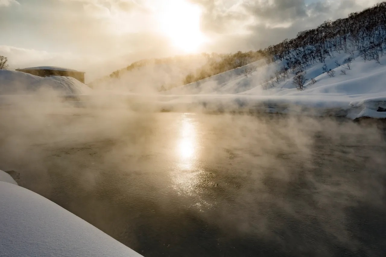
Fifth Water Hot Springs in Diamond Fork Canyon was the first place that really got me hooked on hot springs hiking. The trail is about five miles round-trip with roughly 500 feet of elevation gain, so it is a moderate hike. Specifically, the path follows a creek dotted with small waterfalls. Arriving early is key; otherwise, parking fills up fast. Moreover, the pools vary in temperature, some nearly scalding. Clothing is optional. For example, I once arrived just before sunrise on a Tuesday in October and had the largest, milky-blue pool entirely to myself for nearly an hour. Consequently, the water had a distinct, deep blue-green color due to the rich minerals. That solitary, pre-dawn soak was the perfect mental reset.
Detailed Trail Breakdown for Fifth Water Hot Springs
The main access is the Three Forks Trailhead for a balanced 5-mile out-and-back.
Trail Landmarks and Instructions
- Start and the Diamond Fork River Crossing: From the trailhead, you immediately cross the Diamond Fork River on a sturdy wooden footbridge.
- Junction with Sixth Water Creek: The trail follows a path along Sixth Water Creek. Look for the distinctive junction roughly a mile in, where Sixth Water Creek meets Fifth Water Creek.
- Bridge Over Sixth Water Creek: You’ll cross Sixth Water Creek via a second bridge, and then bear right to track Fifth Water Creek.
- The Sulfur Scent: You will know you are close when you begin to catch the unmistakable, pungent aroma of sulfur.
- Main Waterfall and Pools: The first and largest set of soaking pools are situated just below a cascading hot springs waterfall.
Terrain and Seasonal Variations
The terrain is varied, moving from open valley floor to a tighter canyon. The path is mostly dirt and gravel, although it can become very muddy during spring thaw or after heavy rain. Also, there are two mandatory footbridge crossings. In fact, in Winter, the gate to the main trailhead closes, thereby adding up to 3 miles round-trip; therefore, Microspikes are essential for traction on the icy patches. Furthermore, Fall is my favorite; the cooler air makes the heat of the springs incredibly soothing. Wildlife includes deer and raptors. Look out for snakes, including rattlesnakes, on warm rocks.
Planning and Gear Advice for Fifth Water
Always check trail conditions. There is a pit toilet at the trailhead, but no other facilities. Pack out all trash. Bring a headlamp if hiking before sunrise or near sunset. Sturdy, waterproof hiking boots are best. In addition, for the soak, water shoes or sandals are non-negotiable due to sharp stones or broken glass. Since the water has sulfur, bring a dedicated, dark-colored towel; the sulfur aroma can linger. Finally, the water from the hot springs contains high levels of sulfur and is not safe to drink. For health information, check the Utah Department of Environmental Quality’s recreational monitoring.
Goldbug Hot Springs, Idaho
Goldbug Hot Springs is a hidden gem along the Salmon River. The hike is roughly three miles round-trip, but it includes a rocky, steep final quarter mile. The canyon walls rise dramatically around the trail. As you approach, the pools at Goldbug are tiered along the cliffside. I prefer midweek visits. My favorite moment was discovering the hidden waterfall cave, which is located below the main pools. To see it, I waded through a small, shallow pool to find a tiny waterfall trickling through the cave ceiling.
Detailed Trail Breakdown for Goldbug Hot Springs
The hike is an approximate 3.6-mile out-and-back route with a noticeable 900 feet of elevation gain. Consequently, the steep sections make it a solid moderate challenge.
Trail Landmarks and Instructions
- Private Property Easement: The trail starts on an easement through private property. Follow the clear, signed path.
- Switchbacks and Open Terrain: The initial climb consists of a series of switchbacks through scrubby sagebrush terrain.
- Wooden Bridge and Creek Crossing: You will reach and cross a wooden footbridge over Warm Spring Creek.
- The Steep Stairs Section: The final quarter-mile becomes significantly steeper with constructed wooden steps and natural rocks.
- Reaching the Pools: The pools are tiered along the hillside, and thus offer incredible, panoramic views.
Terrain and Seasonal Variations
The terrain transitions from packed dirt to loose scree and rocky sections. Specifically, the steep, exposed switchbacks are taxing in Summer heat; therefore, start early. Fall is the best time to visit. Conversely, in Winter, snow and ice make microspikes or crampons mandatory for safety on the steep final climb. Scenery is stunning, looking down the Salmon River Canyon. Wildlife may include elk, deer, and high-desert bird species.
Planning and Gear Advice for Goldbug
The trailhead has a vault toilet, but no other amenities. Camping is strictly prohibited within 500 feet of the hot springs. Leave No Trace is paramount here to maintain public access through the private land easement, as advised by the Bureau of Land Management. Sturdy hiking boots with good grip are needed for the steep, rocky section. Finally, water shoes are highly advised for the pools.
Granite Hot Springs, Wyoming
Granite Hot Springs is nestled in the Rockies, a perfect spot for both short hikes and alpine adventures. The trail to the developed pool is about 1.5 miles one-way, moderate in elevation, passing aspen groves and small streams. As a result, the pools are large, warm, and easy to relax in, with surrounding peaks creating a stunning backdrop. Winter trips require significant preparation. Indeed, I spent a long time floating on my back during one winter trip, watching the fine powder snow drift down onto the pool deck. The reward is exponentially greater when you have to work for it.
Detailed Trail Breakdown for Granite Hot Springs
This location features a developed pool and access to the longer Granite Creek Trail into the wilderness.
Trail Landmarks and Instructions
- Access Road and Granite Creek Falls: Access is via an 11-mile drive down the gravel Granite Hot Springs Road. A short, easy trail leads to Granite Creek Falls before the main hot springs.
- Parking Area and Bridge: The developed pool is accessed by walking down and crossing a bridge over Granite Creek.
- The Developed Pool: The main soaking area is a large, man-made concrete pool fed by natural hot water.
- Trailhead to Gros Ventre Wilderness: Just past the developed pool is the official Granite Creek Trailhead for deep alpine adventures.
Terrain and Seasonal Variations
The path to the developed pool is short and well-maintained. However, for the longer hike, the terrain becomes varied: rocky sections and steep alpine meadows. Summer is the easiest time, because the Granite Creek Road is open for vehicle traffic. Winter (Early December to April) is an adventure: the access road closes, consequently requiring the 10-mile road to be traveled by snowmobile, cross-country skis, or fat bike. The setting is classic Rocky Mountain alpine scenery. Moose are frequently sighted near Granite Creek.
Planning and Gear Advice for Granite Hot Springs
Granite is a developed site, which means there is a fee for soaking. Check the Bridger-Teton National Forest for operating hours and road conditions. Reservations are not taken for soaking. For summer hikes, day hiking boots are sufficient. On the other hand, for winter, you need full cold-weather gear, as well as cross-country skis or a snowmobile.
Sykes Hot Springs, California
Sykes Hot Springs is tucked in Big Sur’s Ventana Wilderness, and it requires a commitment: about 20 miles round-trip with significant elevation loss and gain. Therefore, this is a moderate-to-challenging hike. Permits are required if you plan to camp overnight. Along the trail, redwood groves, river crossings, and shaded alcoves keep the hike visually engaging. Moreover, the deep isolation of the canyon was the true luxury of this demanding hike, which made me feel completely disconnected from the world.
Detailed Trail Breakdown for Sykes Hot Springs
This is a true backcountry trip, covering approximately 20 miles round-trip on the Pine Ridge Trail. The elevation change is significant.
Trail Landmarks and Instructions
- Pine Ridge Trailhead: Begin at Big Sur Station. Park and secure your required Wilderness Permit.
- Initial Climb and Redwood Groves: The trail immediately begins to climb through lush, towering redwood groves.
- Barlow Flat Camp and the River: You will pass Barlow Flat Camp before beginning the final, serious descent to the river canyon. The trail has been subject to reroutes due to slides.
- Big Sur River Crossing: The last mile involves a steep descent and a mandatory river crossing to reach the Sykes Camp and the pools. This can be challenging and dangerous, especially during high water.
Terrain and Seasonal Variations
The terrain is varied and rugged, ranging from smooth dirt to loose, rocky stretches. The major obstacle is the Big Sur River crossing. Therefore, trekking poles are crucial for stability on the crossings. Spring and Fall are the ideal times; temperatures are mild and river crossings are usually at their lowest. In contrast, Winter is the most challenging time; heavy rains can cause the Big Sur River to swell into a raging, dangerous torrent. Always check the current trail status. Bear canisters are highly recommended because there are black bears in the area.
Planning and Gear Advice for Sykes
This is an overnight backpacking trip for most. A free Campfire Permit is required, and a Stove Permit is required year-round. No campfires are permitted most of the year. Leave No Trace principles are critical to prevent closure. The Ventana Wilderness Alliance provides up-to-date information on trail alerts. Bring high-quality water filtration and bear-proof food storage (canister).
Goldmeyer Hot Springs, Washington
Goldmeyer is a backcountry classic, about 4.5 miles one-way with moderate elevation gain. As you hike, the trail follows a creek through a lush forest. Permits are required since the springs are privately maintained. The pools are warm, clear, and secluded. The magic of Goldmeyer is the cave pool. Specifically, I ducked through a small opening to find a deeper pool in the dark, intimate cave. The air was thick with humidity, and it felt like being in the earth’s warm core.
Detailed Trail Breakdown for Goldmeyer Hot Springs
A well-preserved, semi-private natural hot spring, roughly 9 miles round-trip with a manageable elevation gain of about 1,000 feet.
Trail Landmarks and Instructions
- Road Closure and Initial Hike: Forest Service Road 52 is subject to closures and washouts, which can add several miles of road walking. Always check the road conditions.
- The Middle Fork Snoqualmie River: The trail is the Middle Fork Trail, running level alongside the river.
- Footbridge and Turn-off: Cross a distinctive footbridge and then take a marked side trail that climbs steeply for the final half-mile.
- Caretaker Check-In: Goldmeyer is privately maintained. You must check in with the caretaker at the small cabin.
- The Springs Area: Consists of a small, man-made pool outside and a natural-rock-walled pool inside a small cave.
Terrain and Seasonal Variations
The terrain is typical of the Cascades rainforest: soft, root-covered dirt with frequent small runoff crossings. Therefore, the trail is consistently damp and potentially slippery. Reservations are mandatory for all visitors and are often booked months in advance. You must apply through the Goldmeyer Hot Springs reservation lottery. Summer is driest, but access road washouts are common. Scenery is classic Pacific Northwest—a dense, moss-draped forest with towering cedars. Black bears are common, so proper food storage is essential.
Planning and Gear Advice for Goldmeyer
You need waterproof hiking boots for the perpetually damp trail. Bring rain gear regardless of the forecast. Cash is required for the day-use fee.
Hot Springs National Park, Arkansas
Hot Springs National Park offers a different experience because it combines hiking with historic bathhouses. Trails vary, and you can walk to Hot Springs Mountain Tower from several trailheads. For my part, I hiked through wooded trails and then soaked in one of the historic bathhouses, which felt like stepping back in time. Ultimately, the combination of quiet nature trails and the ultimate luxury of a deep, warm soak made for a perfectly balanced day.
Detailed Trail Breakdown for Hot Springs National Park
The park offers a unique blend of urban history and natural trails, primarily on Hot Springs and North Mountains. The main trail system is approximately 26 miles of interconnecting loops.
Trail Landmarks and Instructions
- Bathhouse Row Start: Trails ascend directly from behind the historic buildings on Bathhouse Row.
- Hot Springs Mountain Trail: This main trail ascends to the Hot Springs Mountain Tower.
- Tufa Terrace: Look for the Tufa Terrace, where cooled spring water has built up mineral deposits.
Terrain and Seasonal Variations
The terrain is generally moderate with packed dirt and stone paths. Near the main district, trails are wide and sometimes paved. There are no significant creek crossings requiring fording. Spring is the most beautiful time, with dogwood and redbud trees blooming. However, Summer is hot and humid, so hiking is best done in the early morning. Wildlife includes white-tailed deer and armadillos.
Planning and Gear Advice for Hot Springs National Park
This is a National Park, so check current hours and fees. If you plan to use the historic bathhouses, check their individual hours and services; reservations are required for some treatments. Standard day hiking gear is appropriate.
Scenic Hot Springs, Washington
Scenic Hot Springs requires a short, steep hike—about two miles round-trip with a climb of approximately 1,000 feet. The pools are small but warm, and the forested setting feels private. Reservations are mandatory since the springs are privately maintained. The forest felt quiet and ancient on my visit. The best part was sitting in the warm water, listening to the rain gently fall on the tree canopy above—a perfect moment of isolation and peace.
Detailed Trail Breakdown for Scenic Hot Springs
A short, steep hike of about 2 miles round-trip with a climb of approximately 1,000 feet.
Trail Landmarks and Instructions
- Gate and Private Property: The hike begins from a gated area. Stick to the well-used path as this is private property.
- Steep Ascent: The trail immediately starts a steep, relentless climb through a dense, mossy forest.
- The Springs: The hot springs consist of a few small, wooden-sided soaking tubs.
Terrain and Seasonal Variations
The terrain is classic Pacific Northwest: a thick layer of moss and dense dirt, with frequent tree roots and slippery rocks. The hike is short but continuously steep. Reservations are mandatory for all visitors via the Scenic Hot Springs website. Do not trespass. Winter access is dangerous due to snow and ice; Microspikes are necessary.
Planning and Gear Advice for Scenic Hot Springs
Sturdy boots with good tread are crucial for the steep, slippery terrain. Bring a small bag to pack out all trash. Water shoes are recommended for use around the wooden tubs.
Bowen Basin Hot Springs, California
Bowen Basin is tucked into the Sierra Nevada and feels like a private hideaway. The hike is four miles round-trip with moderate elevation, and a short scramble at the end leads to the pool. The granite cliffs around the pool create a serene, secluded setting. The most serene part was listening to the absolute silence—only the sound of the wind and the gentle murmur of the creek nearby. It was true, high-alpine solitude.
Detailed Trail Breakdown for Bowen Basin Hot Springs
A manageable 4-mile round-trip with a gentle, moderate elevation gain across an open meadow.
Trail Landmarks and Instructions
- Trailhead and Open Meadow: The trail begins from a small parking area and immediately enters a vast, open Sierra meadow. The trail here is faint.
- The Granite Scramble: The final section involves a short, steep scramble up a rise defined by granite boulders. You will need to use your hands for stability.
- The Springs: The pools are located near the creek, nestled at the base of the granite cliffs.
Terrain and Seasonal Variations
The terrain is a mix of spongy, grassy meadow and sandy dirt. The last few hundred feet involve a rocky scramble. Late Spring/Early Summer is when wildflowers are at their peak. During winter, the area is typically covered in deep snow, and is only accessible via cross-country skis or snowshoes. The scenery is dominated by the vastness of the High Sierra, with dramatic granite cliffs.
Planning and Gear Advice for Bowen Basin
The hot springs are in the Sierra National Forest. Parking is severely limited; arrive very early. There are no facilities whatsoever, so follow Leave No Trace principles strictly. Wear tall socks or gaiters for protection in the grassy meadow areas.
Alkai Flat Hot Springs, Oregon
Alkai Flat is a short, flat hike—about two miles round-trip—ideal for beginners or a quick soak. The wide-open views are spectacular at sunset. Overall, it’s a simple, low-effort escape. The moment the sun began to drop, the air temperature plummeted, which made the warm pool feel heavenly. As a result, I watched the entire sky turn purple and orange, and then saw countless stars appear overhead.
Detailed Trail Breakdown for Alkai Flat Hot Springs
A very easy, flat walk of approximately 2 miles round-trip with minimal elevation change in the high desert of southeastern Oregon.
Trail Landmarks and Instructions
- Parking and Trailhead: The “trail” is more of a route across the Alkali Flats, navigating around desert scrub.
- The Springs: The pools appear as steam rising from the ground. They are primitive, rock-lined pools built into the marshy ground.
Terrain and Seasonal Variations
The terrain is flat, hard-packed earth mixed with alkali soil, which can be extremely slippery and muddy after rain. The path is exposed to the elements with no shade. Fall is the most popular time due to comfortable daytime temperatures. Access roads can become impassable due to thick mud in Spring. The scenery is defined by the stark, beautiful desolation of the Oregon high desert.
Planning and Gear Advice for Alkai Flat
This is an extremely remote location. Therefore, ensure your vehicle has a full tank of gas and reliable tires. High clearance is recommended for the primitive dirt roads. Located on Bureau of Land Management (BLM) land), familiarize yourself with BLM recreation guidelines. Sunscreen, a wide-brimmed hat, and sunglasses are essential. Water shoes are a must for navigating the muddy, alkaline area around the pools.
Gros Ventre Hot Springs, Wyoming
Gros Ventre lies near Jackson Hole in a mountain valley. The hike is about three miles round-trip with gentle elevation gain, passing streams and meadows. The pools were warm, soothing, and slightly mineral-scented. In fact, as I was soaking, a small herd of elk grazed peacefully on the opposite side of the meadow. The water temperature was perfectly warm, and I felt completely immersed in the Western wilderness.
Detailed Trail Breakdown for Gros Ventre Hot Springs
A relatively easy hike of about 3 miles round-trip through a mountain valley in the Gros Ventre Wilderness.
Trail Landmarks and Instructions
- Trailhead and Valley Floor: The trail begins in the scenic Gros Ventre Valley, moving into open meadows.
- The Springs: The hot springs are typically visible as steam rising from the ground in a marshy area near the riverbank. They are undeveloped, primitive pools often lined with stones.
Terrain and Seasonal Variations
The terrain is mostly packed dirt and soft, grassy meadow paths. The meadow can be extremely muddy in the spring. Mosquitoes can be intense in the damp meadows in Summer. Fall offers beautiful golden foliage. Wildlife viewing is a major feature; Elk, bison, and moose are frequently sighted in the valley meadows. You must maintain a safe distance from all large animals.
Planning and Gear Advice for Gros Ventre
This spring is in the Bridger-Teton National Forest. Check the status of the Gros Ventre River, as it can be prone to flooding. Arrive midweek to avoid the crowds. Bug spray is absolutely mandatory in the summer. Binoculars are recommended for safely viewing the abundant large wildlife.
Waterfalls and Side Hikes
Some hot springs pair beautifully with waterfalls. Conundrum Hot Springs in Colorado is challenging—about 8 miles one-way with 2,800 feet of elevation gain—but the alpine scenery and isolation make it worthwhile. Be sure to plan ahead because permits are required at some locations, clothing norms vary, and I always carry a towel, snacks, and water.
Planning Your Trip
Planning a hot springs hike goes beyond knowing the trail. First, I pack sturdy shoes, layers, towels, snacks, and water. Seasonal timing matters: winter snow, summer mosquitoes, and spring floods can all affect the experience. In all cases, I follow leave-no-trace principles and pace myself to fully enjoy both the hike and the soak.
Wrapping It Up
The U.S. is full of hidden hot springs waiting to be explored. From quick, accessible soaks to challenging alpine adventures, these hikes provide something for everyone. I’ve shared my experience, timing tips, access information, and etiquette advice. Therefore, respect the springs, plan ahead, and enjoy every soak—you’ll find the effort is always worth it.
About the author
Cap Puckhaber is a marketing strategist, finance writer, and outdoor enthusiast. He writes across CapPuckhaber.com, TheHikingAdventures.com, SimpleFinanceBlog.com, and BlackDiamondMarketingSolutions.com. Follow him for honest, real-world advice backed by 20+ years of experience.
A Hiker’s Guide to Active Volcanoes
10 Unforgettable Outdoor Destinations
Join our Mailing List
Sign up with us now and be the first one to know about our exclusive offers and product updates.
By submitting your information, you`re giving us permission to email you. You may unsubscribe at any time.
Follow Cap Puckhaber on Social Media


About the Author: Cap Puckhaber
Backpacker, Marketer, Investor, Blogger, Husband, Dog-Dad, Golfer, Snowboarder
Cap Puckhaber is a marketing strategist, finance writer, and outdoor enthusiast from Reno, Nevada. He writes across CapPuckhaber.com, TheHikingAdventures.com, SimpleFinanceBlog.com, and BlackDiamondMarketingSolutions.com.
Follow him for honest, real-world advice backed by 20+ years of experience.